Showing posts with label Oregon. Show all posts

Saturday, August 22, 2015

The best view on the Oregon Coast from public lodging

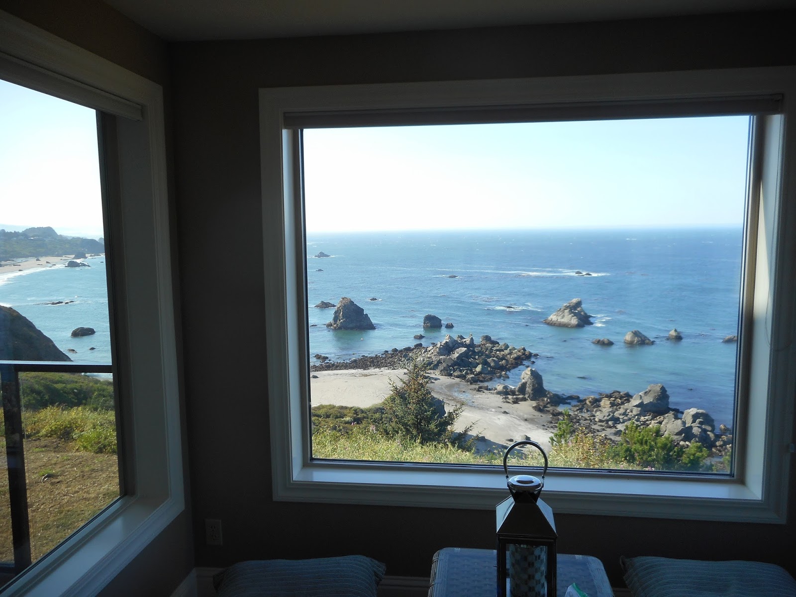
                       The actual view from the window at Toby's Crab Shack.

THE absolute best, No. 1, superior view on the Oregon Coast, available for public lodging is at Rainbow Rock, 3 miles north of Brookings.
I stayed here for 5 days in August of 2015. Having traveled on vacations along the Oregon Coast some 24 times in the past 32 years, I've seen the majority of what's out there -- and the place called Toby's Crab Shack is light years ahead of the rest.
Case in point: My 19-year-old son has always turned the TV on and plopped down on a chair whenever we've stayed anywhere else. 


                 The 2 indoor window seats at Toby's Crab Shack. There's a deck too.

However, at Toby's Crab Shack, he went to the window and sat down and starred. He never ate at the dinner table -- he took his food to the deck or the window chairs.
Now I have not idea why the name Toby's Crab Shack was given to this place. It should be called "The Room with THE view."
You will NEVER want to close the blinds at this place -- just keep the view always open.


Toby's Crab Shack is in the building on the left, second floor, far left (or north end) in these two photographs with a 180-degree clear view of the Pacific Ocean and rocky headlands galore.


Besides the spectacular view, the place has access to a private trail to a remote beach north of Brookings. It also has elaborate accommodations for 4 people (2 bedrooms) and is very affordable when you consider how much plain motels cost along the Oregon Coast.
Now, I'm not paid, affiliated or compensated in any way with or by Toby's Crab Shack. I just think it is a great place to stay and it has redefined my formula for lodging along the Oregon Coast.
The ONLY improvement I'd make in the place is to have a good spotting scope available by the window.
I will return to this place in the future. It is a gem.
Toby's is part of the large complex of condos at Rainbow Rock. It has a locked car gate and is its own private community. It is a very quiet, serene and well kept place.

-If you'd like to look at Toby's Crab Shack as a rental, go to VRBO.com and search for: 

Oceanfront Condo in Brookings at Rainbow Rock

(NOTE: However, children are not allowed at Toby's Crab Shack. Yet, there is another condo for rent by the same company at the south end of Rainbow Rock that caters to families with young children.)


         What the beach below Toby's Crab Shack is like ... My family members were often the only people there, even on a warm summer day.

Tuesday, June 24, 2014

Some Oregon Coastline Eroding Pretty Quickly

                            Ecola State Park, looking southward.

DURING a June 2014 visit to the Oregon Coast, I realized more than ever before how vulnerable the coastline is to erosion.
While Cape Foulweather and the Seal Lion Caves appear to be built on bedrock, many other places are not.
Classic example: Ecola State Park's south side facing Cannon Beach.
Through the 1980s, you could climb down a nice trail from Ecola to the far north edge of Cannon Beach. (I still have watchable videos of playing on the beach area.)
However, in the early 1990s, that area had a slide and has never been rebuilt as a trail downward.
Jump to August of 2013 and yet another slide, this one further to the west, took out the trail in Ecola where you can view the lighthouse. It has been closed ever since and may never be opened again.
That's some dramatic change in just 26 or so years.

                               Inside the Devil's Punchbowl at low tide.

Go south to Devil's Punchbowl and at the main cliff lookout, you can spot old asphalt over the fenceline, where the fence used to be 10 or so feet further out to the west.
Some vintage photographs from the 1910s also show formations on nearby area beaches, like the Sphinx, that no longer exist, being all eroded away by the water.
--As a sidenote, the Oregon Coast is so dramatic mostly because of all the cliffs and rocks that jut out along the coastline. That's all thanks to an ancient lava flow that created them.
--Also, Cape Foulweather is now owned an operated by the Oregon State Parks Department. So, there's less gift show there now,in favor of having an observation room, complete with binoculars to better enjoy that lofty height.

Sunday, September 29, 2013

Crater Lake: The Mountain That Isn't There

                                    Crater Lake as it often appears in mid-May.


Crater Lake is Oregon's only national park, but it is a beauty!
It is a worthy tourist destination, though it can snow there about any month of the year.
Most years, it is July before the snow has melted away.
Notwithstanding, the snow cover offers its own great views of this unusual lake.
Crater Lake is the deepest lake in America, at 1,943  feet (and ninth deepest lake in the world).
Its vibrant blue color and water clarity is unparalleled in most of the world today.
The lake's original name as "Deep Blue Lake" when it was discovered by White Men in 1853. The lake was also called "Blue Lake" and "Lake Majesty," before the Crater name stuck.
(Native Americans considered the area sacred and did not tell outsiders about it.)


  Crater Lake is the remnant of a huge, ancient volcano, Mount Mazama. A gigantic eruption about 7,700 years ago led to the collapse of the crater.
This "Mountain that isn't" was almost 12,000 feet in elevation.
With no inlet or outlet, the area's massive snowfall and precipitation, some 524 inches a year, filled it with water in an estimated 250 years after the volcano collapsed.
Evaporation and seepage keep the lake's water level almost perfectly balanced.
The National Park Services strives to keep pollution from seeping into the lake. The lake's record clarity was to 134 feet in clear depth in the mid-1990s.
 This is a high-elevation lake. The Crater Lake Rim Village sits at an elevation of 7,100 feet above sea level.


  The Crater Lake Lodge opened in 1915. It has been remodeled lots over the years, but typically withstands a snowfall of 15 feet on top.
 Crater Lake is from 4.6 to 6 miles wide. Its water temperature ranges from 32 degrees to 66 degrees.
There are some hydrothermal vents at its bottom.
  The lake contains some 5 trillion gallons of water. If its caldera every broke, a huge flood will result below.
  The shallowest portion of the lake goes from just 15-25 feet.
  A 33-mile loop road circles the lake, but is only open from late spring and summer to early fall.
  A tour boat seasonally operates on the lake.
  A 1.1 mile hike down to the water level at Cleetwood Cove offers not only the seasonal boat opportunity, but the only chance to touch its waters. That hike includes an 11 degree incline, dropping some 600 feet in elevation.
The tallest rim mountain is Hillman Peak at 8,151 feet. (There are taller peaks in the park, away from the rim.)


                                               Deep snow lingers here into late spring.

 Crater Lake is located about 60 miles northwest of Kalamth Falls (elevation 4,100 feet), or about 80 miles northeast of Medford (elevation 1,350 feet).
So, the drive from Medford is almost 6,000 feet upward and from Kalamath Falls, it is about 3,000 feet upward.
If traveling the Medford route, be sure to check out some Rogue River scenic points along the roadway.
Deep snowwalls along side the road highlight the upper portion of the road from Kalamath Falls.


 Wizard Island 


                                   Visit in mid-May and a lot of options will still be closed.


          Compare the 2nd photo up with this photo to imagine the vanished Mount Mazama.